 GHGSat is a Canadian satellite operator and analytics provider that has built the world’s largest commercial constellation dedicated exclusively to greenhouse gas monitoring, combining high-resolution methane and CO2 measurements from orbit with the same sensor deployed on aircraft.
Yes, it is a legitimate company, privately held and headquartered in Montreal since 2011, with over $173 million CAD raised, a named customer list that includes ExxonMobil and Aramco, and data science partnerships with NASA and ESA.
This review covers GHGSat’s constellation, sensor technology, product line, pricing model, and real limitations, so you can judge whether it is the right fit for your emissions monitoring program.
Table of Contents
Key Takeaways
- GHGSat is the specialist choice for buyers who need facility-level methane and CO2 point-source detection from space
- Its standout edge is the patented WAF-P spectrometer at ~25 m resolution, roughly 100× finer than other satellite GHG systems
- The key caveat: GHGSat publishes no rates of its own, so buying direct starts with a sales conversation
About GHGSat
GHGSat Inc. built its business around a single, deeply specialized problem: measuring greenhouse gas emissions from orbit with enough resolution to attribute them to individual industrial facilities and equipment. That focus shapes every part of its product architecture, and the key facts below are drawn from GHGSat’s own published pages and press releases as of June 2026.
| Name | GHGSat |
|---|---|
| Website | ghgsat.com |
| Legal name | GHGSat Inc. |
| Address | 1130 Sherbrooke Street West, 15th Floor, Montreal, Quebec H3A 2M8, Canada |
| Founded | 2011 |
| Ownership | Private (backed by Yaletown Partners, Fonds de solidarité FTQ, BDC Capital, National Bank of Canada, Export Development Canada) |
| Leadership | Stephane Germain (Founder, CEO & President); Jeffrey Kadanoff (CFO); Eric Edwards (CTO); Emilie Hamel (COO); Deepak Anand (CCO); Sonia Kim (CPO); Dan Wicks (Managing Director, GHGSat UK) |
| Products & data | DATA.SAT (satellite methane); DATA.SAT CO2 (C10 Vanguard); DATA.AIR (airborne); Global Survey; GHGSat Data Archive; SPECTRA methane map; Emissions Analytics |
| Pricing | Subscription-based, flexible campaign plans; no prices published; contact for quote |
| Languages | English, French |
GHGSat’s own constellation page reports 4.18 million facility measurements delivered in 2024, with more than 20,000 super-emitter events (above 100 kg/hr) detected that year. The company also reports having supported the mitigation of over 20 million tonnes of CO2 equivalent of methane since beginning operations, a figure cited in its own press releases. Offices are maintained in Montreal, Houston, Calgary, London, and Ottawa, with more than 150 employees.
Is GHGSat legit?
GHGSat’s legitimacy is well established by any standard measure. The company has operated continuously since its technology demonstrator launch in 2016, has 16 satellites in orbit, and holds data science partnerships with NASA and ESA, partnerships that no credible regulator or research agency would grant to an unreliable operator.
Ownership and funding
GHGSat Inc. is a private Canadian technology company that has raised $173 million CAD in equity and debt financing since its founding in 2011. The most recent disclosed round was $47 million CAD in convertible notes and debt announced in 2025, led by Yaletown Partners on the equity side and National Bank of Canada on the debt side. Additional investors include Fonds de solidarité FTQ, BDC Capital, and Export Development Canada.
The company has subsidiaries in Houston (GHGSat (US) Incorporated) and London (GHGSat UK), with its institutional investor roster providing a clear counterparty footprint for enterprise procurement teams.
As a private company, GHGSat does not file public quarterly reports, but its funding history, investor roster, and subsidiary structure provide a clear institutional footprint for enterprise buyers evaluating counterparty stability. The company has been named to the Deloitte Fast 500, the Fortune Change the World list, and the Financial Times Americas Fastest Growing Companies 2026.
Track record and customers
GHGSat’s named customer list anchors firmly in the oil and gas sector: ExxonMobil, Aramco, the National Gas Company of Trinidad and Tobago, Comstock Resources, and SOCAR via the Oil and Gas Climate Initiative. The September 2025 ExxonMobil partnership, covering onshore operations across the United States, Canada, Papua New Guinea, and Indonesia, is one of the largest publicly disclosed commercial methane monitoring deployments in the sector.
Scientific validation is provided through a December 2025 paper co-authored by GHGSat, SRON Netherlands Institute for Space Research, and Carbon Mapper, published in Science, estimating that 3,114 oil, gas, and coal sites worldwide emitted 8.3 million tonnes of methane in 2023 based on GHGSat satellite data.
Compliance and data rights
GHGSat’s data access model is enterprise subscription-based, with no self-serve e-commerce on the site. The entry point is a contact or demo form. The company operates research-grade non-commercial data access tracks in partnership with NASA, ESA, and UK Space Agency, which distinguishes its data quality and calibration pedigree from purely commercial-only providers. Pricing and licensing terms are disclosed directly to enterprise buyers rather than posted publicly, consistent with the B2B government and energy-sector customer base.
Data and capabilities
GHGSat’s entire product architecture is built on a single proprietary sensor, the patented Wide-Angle Fabry-Perot (WAF-P) imaging spectrometer. That sensor flies on every satellite in the constellation and on aircraft, which means cross-platform calibration is a built-in technical advantage that multi-vendor methane programs cannot replicate.
The WAF-P sensor and what it measures
What I would flag before anyone budgets for this is that the frame size decides the workflow. A roughly 12 km by 12 km scene at 25 m is an instrument for interrogating a known site, not for finding an unknown one, so my advice is to bring the coordinates and let a wide-swath public sensor do the searching.
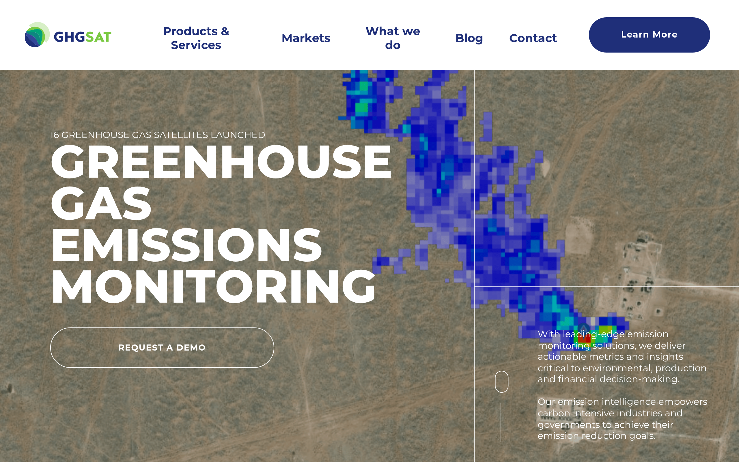
The WAF-P spectrometer measures sunlight absorption at methane wavelengths at very high spectral resolution, providing quantitative methane concentration values across more than 200,000 pixels per image at approximately 25 m spatial resolution. GHGSat advertises a detection floor of as small as 100 kg/hr, often attributable to individual pieces of equipment.
That resolution figure is roughly 100 times finer than lower-resolution satellite GHG detection systems, which is what makes facility-level attribution possible rather than only basin or regional-scale mapping.
The aircraft variant of the same WAF-P sensor operates from approximately 10,000 feet altitude and achieves spatial resolution finer than 1 m, enabling targeted follow-up campaigns at sites flagged by the satellite network with a continuously calibrated instrument chain between the two platforms.
Constellation and revisit
As of November 28, 2025 (SpaceX Transporter-15), GHGSat has 16 satellites in orbit: 15 dedicated to methane monitoring and one (GHGSat-C10 “Vanguard”) providing the world’s first commercial high-resolution CO2 monitoring sensor. All are in sun-synchronous polar orbit at approximately 500 km altitude.
The company’s own press release for the Transporter-14 launch in June 2025 confirmed that the 14-satellite fleet enabled daily monitoring capability for carbon-intensive industrial facilities globally, a claim extended to the current 16-satellite constellation. GHGSat has announced plans to nearly double the constellation size by late 2026.
The satellite generations span from the technology demonstrator GHGSat-D “Claire” (2016) through the most recent Transporter-15 pair, with sensor payloads for the C9-C11 batch built by ABB in Canada and integrated into Spire Global satellite buses. Each satellite is named after a child of a GHGSat employee, a detail that reinforces the company’s founder-led culture rather than being operationally significant, but it is consistent with how the company presents its mission publicly.
Products and data access
GHGSat’s commercial product line spans four primary tiers. DATA.SAT delivers satellite methane data in three formats: Abundance Dataset, Concentration Map, and Emission Rates. DATA.SAT CO2 provides the same output set for CO2 via the C10 Vanguard sensor. DATA.AIR covers targeted airborne campaigns using the same WAF-P sensor at aircraft altitude. Global Survey is designed for fleet-wide monitoring across large asset portfolios, enabling systematic facility coverage rather than on-demand single-site tasking.
The GHGSat Data Archive provides access to historical satellite observations by time period and region. SPECTRA is the company’s global methane concentration visualization product. Emissions Analytics layers custom analytics combining satellite, aircraft, and third-party data for hotspot detection, leak risk scoring, and predictive modeling. Data is delivered to clients within hours of detection, per GHGSat’s own product pages.
Pricing
GHGSat publishes no prices of its own, and buying direct means a subscription. The UP42 marketplace lists its data at published credit rates: catalog from 554,400 credits per scene, tasking from 443,500. Direct, the pricing model is subscription-based, with what GHGSat’s own product pages describe as “different subscription plans available to meet data campaign objectives.” DATA.AIR airborne campaigns are billed separately from satellite subscriptions, and the Global Survey product represents a distinct service tier from single-facility DATA.SAT subscriptions. The entry point for all commercial inquiries is the contact form at ghgsat.com.
| Product | Model | Published rate | Notes |
|---|---|---|---|
| DATA.SAT (satellite methane) | Subscription campaign | Contact for quote | Flexible plans, Abundance Dataset, Concentration Map, Emission Rates outputs |
| DATA.SAT CO2 | Subscription campaign | Contact for quote | Via GHGSat-C10 Vanguard, same output formats as methane product |
| DATA.AIR (airborne) | Campaign-based | Contact for quote | Billed separately from satellite subscriptions, targeted survey campaigns |
| Global Survey | Subscription / portfolio | Contact for quote | Fleet-wide monitoring for large asset portfolios, systematic coverage |
| GHGSat Data Archive | On request | Contact for quote | Historical observations by time period and region |
| Emissions Data Science Partnerships | Non-commercial | Research access | NASA, ESA, and UK Space Agency research-grade data access tracks |
The absence of published pricing is standard for this segment of the market, where contract scope, facility count, geographic coverage, and revisit frequency all vary significantly between customers. Enterprise oil and gas operators, utilities, and regulators typically negotiate multi-year portfolio agreements rather than transactional per-measurement pricing.
Buyers who want a budget estimate before engaging sales should come prepared with facility count, sector, and monitoring frequency requirements to get a meaningful indicative range in the first contact.
Non-commercial research access through the NASA, ESA, and UK Space Agency partnerships provides an academic and government route to the data without a commercial subscription, which is relevant for regulators and research institutions with limited procurement budgets.
Who it’s for
GHGSat’s product architecture maps onto a narrow, high-value set of buyer segments. The common thread is a need for quantified, facility-attributed emissions data with a defensible measurement methodology, whether that need is driven by regulation, ESG reporting, operational efficiency, or scientific research.
Oil and gas operators
Upstream and midstream operators running methane leak detection and repair (LDAR) programs represent GHGSat’s core commercial segment. The 25 m resolution is what makes the difference here: it enables attribution of a detected emission to a compressor station, a storage tank, or a pipeline segment rather than only to a basin or a county.
Named customers ExxonMobil, Aramco, Comstock Resources, and the National Gas Company of Trinidad and Tobago all sit in this category, and the ExxonMobil deployment covering four countries across two continents confirms that the platform scales to multi-asset global programs.
OGMP 2.0 certification support is explicitly listed as a use case, which is relevant for operators in jurisdictions where the Oil and Gas Methane Partnership 2.0 framework is becoming the reporting standard of record.
Regulators, governments, and ESG investors
National emissions inventory development and validation, government emissions verification programs, and sustainable finance ESG data pipelines are all explicitly documented use cases. The data science partnerships with NASA, ESA, and the UK Space Agency provide the independent methodological validation that government and financial institution customers typically require before accepting third-party emissions data in a regulatory or reporting context.
The December 2025 Science paper quantifying 8.3 Mt of methane from 3,114 sites in 2023 positions GHGSat data within the peer-reviewed scientific literature, which adds credibility for buyers whose downstream use requires methodological defensibility.
Coal, waste, power, and industrial sectors
Beyond oil and gas, GHGSat documents coal mining methane monitoring, waste management and landfill gas monitoring, and CO2 monitoring for power generation and heavy industry (cement, steel, aluminum) via the C10 Vanguard CO2 sensor. These are smaller segments of the current customer base but expanding markets as industrial decarbonization reporting requirements tighten. Agriculture methane monitoring rounds out the use case list.
Where it’s less competitive
GHGSat is a single-modality provider: it measures greenhouse gas concentrations, not optical imagery, SAR, or any other EO data type. Buyers who need multi-sensor EO programs covering land use, flood mapping, crop monitoring, or infrastructure surveillance will need separate providers for those requirements.
The 12 by 12 km approximate scene footprint is well matched to facility-level monitoring but not to basin-scale or continuous-coverage mapping workflows that require wide-swath sensors. GHGSat’s own sales-led pricing also means that buyers who need a firm budget number before initiating a procurement process will have to go through the sales cycle to get it.
Strengths and limitations
GHGSat’s position as the originator of commercial high-resolution satellite methane monitoring creates a set of structural advantages that competitors have not yet fully replicated. The strengths concentrate in sensor precision, cross-platform continuity, and track record:
- World’s largest commercial constellation dedicated exclusively to GHG monitoring (16 satellites as of November 2025), with daily revisit capability for carbon-intensive industrial facilities globally
- Patented WAF-P spectrometer at ~25 m resolution enables direct attribution of emissions to individual facilities and equipment, with an advertised detection floor as small as 100 kg/hr methane
- Unique cross-platform sensor architecture: the identical patented instrument operates from both satellite (~500 km) and aircraft (~10,000 ft), providing continuous calibration between the two measurement channels
- World’s first commercial high-resolution CO2 satellite sensor (C10 Vanguard, launched November 2023), extending the platform from methane to industrial CO2 monitoring
- Data science partnerships with NASA, ESA, and UK Space Agency, and peer-reviewed Science paper publication, provide methodological validation that is rare among commercial EO operators
- Constellation expansion to nearly double current size by late 2026 is published plans, adding revisit density and geographic redundancy
The limitations are worth mapping directly against your program requirements before initiating a procurement process:
- GHGSat publishes no rate card: subscription plans require a sales conversation, and the only published per-scene numbers sit on the UP42 listing
- Single-modality: GHGSat measures GHG concentrations only, with no optical imagery, SAR, or multi-spectral data products; buyers with multi-sensor EO needs require additional providers
- The approximately 12 by 12 km scene footprint limits utility for wide-area basin-scale or continuous-coverage mapping, as the sensor is optimized for facility-level point-source attribution rather than regional background concentration mapping
- Satellite count is growing and may be higher than the 16 reported as of November 2025 by the time you read this, so buyers planning around specific revisit frequency should confirm current constellation status directly with GHGSat
The core commercial tension is between GHGSat’s unmatched facility-level precision and its deliberately narrow scope. For programs where quantified, equipment-attributed methane detection is the requirement, no commercial satellite operator delivers equivalent spatial resolution. For programs where GHG monitoring is one input among several EO data types, GHGSat works best as a specialist layer within a multi-provider stack.
GHGSat alternatives
If GHGSat’s narrow-beam facility-level architecture does not fit your requirement, three active providers offer meaningfully different capability profiles in the GHG and methane monitoring space. The table below draws on verified specifications from primary sources for each provider.
| Provider | Technology | Resolution / footprint | Coverage model | Key differentiator |
|---|---|---|---|---|
| GHGSat | WAF-P spectrometer satellite + aircraft | ~25 m, ~12×12 km scene | Daily facility monitoring, tasked campaigns | Highest-resolution commercial GHG satellite, cross-platform (satellite + aircraft) calibration, CO2 and CH4 |
| Carbon Mapper | Hyperspectral imaging spectrometer (Tanager-1 via Planet) | 30 m, 18 km swath | Weekly global revisit, wide-swath passes | Wide-swath VSWIR (400–2,500 nm) covers methane plus CO2, vegetation, and other applications. JPL-engineered sensor |
| Kayrros | Analytics layer over multiple satellite datasets (Sentinel-5P, TROPOMI, Sentinel-2, SAR) | Varies by input dataset (km-scale to ~10 m) | Continuous global asset monitoring | Multi-source analytics fusion covering methane, deforestation, and energy infrastructure without owning satellites |
| Orbital Sidekick | GHOSt hyperspectral constellation (VNIR plus SWIR) | ~8 m GSD | Persistent monitoring of energy corridors | Commercial hyperspectral methane and hydrocarbon leak detection focused on pipelines and energy infrastructure |
Carbon Mapper (operating Tanager-1 via Planet Labs) delivers wider-swath methane and CO2 detection at 30 m resolution across an 18 km swath, with weekly global revisit, making it well suited for programs that need broader geographic coverage per pass rather than facility-specific pinpoint attribution.
Kayrros takes a different approach entirely, fusing multiple existing satellite data streams through an analytics layer rather than operating its own sensors, which suits buyers who want cross-asset methane and energy infrastructure monitoring without a direct satellite subscription. Orbital Sidekick operates its GHOSt hyperspectral constellation for commercial methane and hydrocarbon leak detection, focused on pipeline and energy-infrastructure corridors rather than basin-scale survey, serving operators whose primary need is facility-level attribution along their own assets.
GHGSat’s differentiation holds for buyers where the 25 m facility-level resolution and the cross-satellite-aircraft calibration chain are decision drivers. For buyers where regional coverage breadth, data fusion across multiple sensors, or open-access data are the priority, one of these three alternatives is likely a better starting point.
For how GHGSat fits the wider market, browse our Earth observation provider guides.
Verdict
Legitimacy is not a serious question with GHGSat: it is a private Canadian company that has operated continuously since 2016, has 16 satellites in orbit, holds research partnerships with NASA and ESA, and counts ExxonMobil and Aramco among its named customers. The real evaluation question is whether its specialized, high-resolution point-source architecture fits your monitoring program.
For oil and gas operators running LDAR programs, industrial emitters needing facility-level CO2 and methane attribution for ESG reporting, or government buyers building national emissions verification capacity, GHGSat is the most capable single-vendor solution for satellite-based point-source detection at 25 m resolution. The cross-platform aircraft-plus-satellite architecture and the NASA, ESA, and peer-reviewed science credentials provide a methodological pedigree that matters for regulatory and financial reporting contexts.
The caveats are structural. GHGSat publishes no rates itself, so buyers who want a published number before opening a procurement process will find it on the UP42 listing rather than on ghgsat.com. GHGSat is a single-modality provider, so any EO requirement beyond greenhouse gas concentration measurement requires a separate vendor. For programs where wide-swath regional coverage matters more than facility-level attribution, Carbon Mapper better fits the geometry.
For buyers whose core need is high-resolution, facility-attributed methane and CO2 monitoring from space, GHGSat is the benchmark provider in that specific category.
Frequently asked questions
Below are answers to the questions buyers most commonly ask about GHGSat. Each answer points to the section where the full detail lives.
How does GHGSat work?
GHGSat satellites carry a patented Wide-Angle Fabry-Perot (WAF-P) imaging spectrometer that measures sunlight absorption at methane (and CO2) wavelengths from orbit at approximately 25 m spatial resolution. Buyers commission monitoring campaigns or subscribe to ongoing facility surveillance, the satellite constellation tasks the relevant sites, and data is delivered within hours of detection through GHGSat’s platform. The same sensor operates on aircraft for targeted follow-up campaigns. Full detail is in “Data and capabilities“.
Is GHGSat a legit company?
Yes. GHGSat Inc. is a private Canadian technology company founded in 2011, with 16 satellites in orbit as of November 2025, over $173 million CAD raised, and named enterprise customers including ExxonMobil and Aramco. Its data science partnerships with NASA and ESA and a co-authored paper in Science (December 2025) confirm institutional scientific credibility. See “Is GHGSat legit?“
Who owns GHGSat?
GHGSat Inc. is a privately held Canadian company with no public parent or controlling single shareholder listed on its site. It is majority-funded by institutional investors including Yaletown Partners, Fonds de solidarité FTQ, BDC Capital, National Bank of Canada, and Export Development Canada. The company was founded and is still led by Stephane Germain as CEO and President. Ownership details are in “Is GHGSat legit?“
How much does GHGSat cost?
GHGSat publishes no prices of its own: subscriptions are quote-based, with DATA.AIR airborne campaigns priced separately from satellite subscriptions. Its satellite data is also sold on the UP42 marketplace at published credit rates (catalog from 554,400 credits per scene). The entry point is the contact form at ghgsat.com, and buyers should come prepared with facility count, sector, and revisit frequency requirements to get a meaningful quote. Full context is in “Pricing“.
Does GHGSat have a free tier?
There is no commercial free tier. Non-commercial research access is available through GHGSat’s data science partnership programs with NASA, ESA, and UK Space Agency, which provide research-grade data access outside the commercial subscription model. This track is relevant for academic institutions, government research bodies, and regulators with non-commercial data needs. Details are in “Pricing“.
Who are GHGSat’s customers?
GHGSat’s own press releases name ExxonMobil, Aramco, the National Gas Company of Trinidad and Tobago, Comstock Resources, and SOCAR (via OGCI) as commercial customers, alongside non-commercial partners NASA, ESA, and UK Space Agency. The customer base is concentrated in oil and gas, with expanding coverage in coal, waste, power, and industrial CO2 sectors. Full context is in “Is GHGSat legit?“
How does GHGSat make money?
GHGSat’s primary revenue model is B2B subscription contracts: enterprise oil and gas operators, industrial emitters, utilities, and governments subscribe to ongoing satellite monitoring campaigns or purchase targeted airborne survey campaigns through DATA.AIR. No self-serve e-commerce exists, and all contracts are negotiated directly with the sales team. As a private company, GHGSat does not publish financial results. See “Pricing“.
When was GHGSat founded?
GHGSat was founded in 2011 by Stephane Germain, who remains CEO and President. The company launched its technology demonstrator satellite, GHGSat-D “Claire,” in June 2016, making it the world’s first company to launch a commercial GHG-monitoring small satellite. Background is in “About GHGSat“.
Where is GHGSat based?
GHGSat’s global headquarters is at 1130 Sherbrooke Street West, 15th Floor, Montreal, Quebec, Canada. The company also operates offices in Houston, Calgary, London, and Ottawa, with subsidiaries GHGSat (US) Incorporated in Houston and GHGSat UK in London. Details are in “About GHGSat“.
What are the best alternatives to GHGSat?
The closest matches depend on your primary requirement: Carbon Mapper for wide-swath 30 m methane and CO2 detection with weekly global revisit, Kayrros for multi-source GHG analytics fusion without direct satellite ownership, and Orbital Sidekick for commercial hyperspectral methane and hydrocarbon leak detection along pipelines and energy infrastructure. A full comparison is in “GHGSat alternatives“.
What use cases is GHGSat best suited for?
GHGSat is strongest for oil and gas LDAR programs requiring facility-level methane attribution, industrial CO2 monitoring for ESG reporting, government emissions verification and national inventory development, and OGMP 2.0 certification support. It is less suited for buyers who need wide-swath basin-scale regional coverage or multi-sensor EO programs beyond greenhouse gas detection. Details are in “Who it’s for“.

My passions are Earth Observation and Satellites, and my profession is Data Analysis. I combine both within ObservationData.com to show you the use cases of Earth Observation, to help you find the right provider, and to share your experiences.