
Flood, fire and earthquake damage spreads where ground crews cannot reach quickly or safely.
Satellite data images the same ground despite blocked roads or restricted airspace.
This guide matches disaster response tasks to the right data and provider.
Table of Contents
Key takeaways
- Disaster response depends on a dated image from before the event, not just a fast one after it
- Free activation reaches registered authorities only, so private buyers rely on commercial tasking
- The shortlist narrows fast once you know whether the job needs all-weather SAR or fast VHR optical
Before any provider enters the picture, a disaster response program has to settle what it needs from the data itself. The summary below sets out the sensors, resolution, and speed that disaster response depends on.
| Primary sensors | SAR, VHR optical, thermal infrared |
|---|---|
| Working resolution | 0.25-1 m tasked, 10-30 m routine |
| Typical revisit | Within hours through tasked SAR or optical |
| Core indices | SAR backscatter change, hotspot temperature, NBR |
| Entry cost | Free for authorities, or from $2,700 per year |
| Main constraint | Free mechanisms exclude private buyers |
Those figures cover the fastest and the cheapest ends of this market. Programs that depart from them, through insurance claims work, structural forensics, or weeks of repeat monitoring, change both the sensor mix and the cost.
How satellite data is used in disaster response
Satellite data enters a disaster response program at several distinct points, before, during, and after an event, each relying on different sensor types and different delivery speeds.
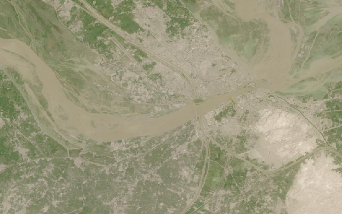
Flood extent mapping with SAR
Floods almost always arrive with cloud cover, which is why SAR, not optical imagery, is the default sensor for mapping how far water has spread. Radar images through cloud and at night, so a monitoring pass never has to wait for clear skies.
ICEYE reports flood data covering 177,159 buildings after Hurricane Helene, with extent reaching FEMA within 24 hours. Munich Re has since folded ICEYE’s flood data into its own risk platform, and building-level flood depth is now a standard line in ICEYE’s insurance offering.
Capella Space lists flood mapping alongside insurance loss assessment among its own use cases, running the same SAR tasking used for structural damage over a flooded area instead of a collapsed building.
Wildfire detection and burn severity
Detecting an active fire is a thermal problem, not an optical one: flame and hot ash radiate strongly in the mid-infrared long before smoke would hide them from a camera. OroraTech operates a purpose-built thermal satellite constellation designed specifically to find hotspots as small as 4 x 4 m.
Its on-board AI compresses each detection and relays fire coordinates within about 3 minutes of the satellite’s overpass, without waiting for a ground station to come into view. Once a fire is out, the same platform’s Burnt Area analytics product turns the hotspot record into a perimeter and severity picture used for planning recovery.
Greece’s Hellenic Fire System, delivered in May 2026 under a €20 million contract, gave the country’s fire service a dedicated version of the same detection architecture covering 100 percent of Greek territory.
Earthquake and structural damage assessment
A collapsed roof, a leaning wall, or rubble blocking a street is a local, visual signature that needs resolution fine enough to see the building, not a wide-area index. Vantor, the imagery business formerly known as Maxar Intelligence, delivers 30 cm-class imagery within 15 minutes of collection through its WorldView constellation’s Direct Access program, for customers with their own receiving equipment, or within a guaranteed six hours through Rapid Access.
That comparison only works against an existing “before” image. Vantor makes part of its archive available through an Open Data Program aimed at disaster response, and its Sentry product runs continuous change detection across hundreds of sites at once, so a baseline is often already on file before a quake hits.
When dust, smoke, or nightfall follows a major quake, as it often does, optical sensors go blind. Capella Space markets its SAR constellation for exactly that scenario, confirming a new tasking request in under 20 minutes regardless of what the sky is doing overhead.
Weather forecasting and early warning
Not every satellite contribution to disaster response happens after the event. Forecasting where a hurricane will make landfall, or how fast a storm system will intensify, depends on continuous atmospheric measurement from orbit, a different sensing job from imaging the ground below.
Tomorrow.io operates its own constellation of weather-sensing satellites, a mix of Ka-band radar and passive microwave sounders, and reached a 60-minute global revisit in January 2026. The sounder data feeds atmospheric temperature, water vapor, and precipitation profiles that NOAA has operationally validated through its AWIPS2 system.
That data supports the preparedness side of the response cycle, the forecasting and early-warning work that sets evacuation timing before any ground imagery is needed at all.
Free activation mechanisms and their limits
Two public mechanisms sit underneath this entire commercial market, and both are free at the point of use. The International Charter Space and Major Disasters lets registered users, typically national disaster management authorities, report a disaster through a single access point that runs 24 hours a day, seven days a week, at no cost to the user.
Delivery arrives as analyzed disaster maps covering the affected area within a matter of hours or days. The European Union runs a parallel service, Copernicus Emergency Management Service Mapping, a free-of-charge mapping service for natural hazards, human-made emergencies, and humanitarian crises, split into Preparedness, Emergency Response, and Recovery activations.
Neither mechanism is a market entry point for a business. Only Authorised Users can request a Copernicus EMS activation, a list that runs from national focal points to EU delegations, and the Charter’s single access point is built for a registered national authority, not for an insurer assessing a claim or a builder checking a site. That gap, more than the free tier itself, is where the commercial market covered below operates.
Rapid tasking and revisit when the sky is closed
Outside an activation, or for coverage repeated over weeks rather than delivered once, a commercial tasking order is the only route to a fresh image on demand, and cloud cover is the most common reason that order has to be radar rather than optical.
ICEYE runs its SAR constellation on daily to sub-daily coherent revisit over a monitored area and defaults to an eight-hour delivery window from acquisition, averaging under four hours in practice.
For one wide area rather than a single target, Umbra’s Scan mode covers up to 8 by 100 km per pass at 50 cm to 2 m resolution, and unlike most SAR operators it prices that from a published rate starting at $1,250 per scene instead of a quote.
What satellite data you need for disaster response
Different disaster response tasks call for different sensor modalities, resolutions, and revisit speed, and matching the wrong one to the task wastes the hours a response team does not have. The table below maps each common task to the data specifications it requires.
| Task | Sensor modality | Resolution | Revisit | Key index / band |
|---|---|---|---|---|
| Flood extent mapping | SAR (C-band or X-band) | 10-30 m | Daily to per-event | Backscatter, water extent |
| Building-level flood depth | VHR SAR or optical | 0.25-1 m | Per-event, tasked | Depth model, DEM fusion |
| Wildfire hotspot detection | Thermal infrared | 4×4 m hotspot | Sub-daily to near real-time | Brightness temperature |
| Burn severity and extent | Multispectral optical | 10-30 m | Post-event | NBR, dNBR, burnt area |
| Earthquake structural damage | VHR optical | 0.3-0.5 m | Same-day, tasked | Change detection, collapse ID |
| All-weather damage assessment | SAR | 0.25-1 m | Multiple times daily, tasked | Coherent, incoherent change |
| Hurricane and storm forecasting | Ka-band radar, microwave sounder | 5-28 km | 60-min global revisit | Atmospheric soundings |
| Wide-area disaster mapping | SAR (wide-swath scan) | 0.5-2 m | Per-event, tasked | Large-area backscatter mosaic |
| Free emergency mapping | Multi-sensor, contributed | Varies by contributor | Hours to days | Analyzed disaster maps |
With the data requirements mapped, the next step is identifying which providers can supply them. The section below covers operators relevant to disaster response, from SAR and VHR optical constellations to a dedicated thermal and an aerial specialist.
Satellite data providers for disaster response
The providers below have documented disaster response use cases and data products that map to the tasks in the table above. The mix spans SAR and optical satellite operators, a dedicated thermal constellation, and an aerial specialist built for post-disaster claims work.
| Provider | Type | Best for | Key disaster spec | Entry point |
|---|---|---|---|---|
| ICEYE | SAR satellite operator | Flood and hurricane response | Building-level flood depth | Quote or UP42 marketplace |
| Capella Space | SAR satellite operator | Fast all-weather damage assessment | Sub-20-min tasking confirmation | Quote or UP42 marketplace |
| Vantor | Optical satellite operator | Rapid VHR damage assessment | 15-min Direct Access delivery | Quote or UP42 marketplace |
| Planet | Satellite operator | Pre-disaster baseline imagery | PlanetScope 3-3.7 m, near-daily | Imagery from $2,700 per year |
| OroraTech | Thermal satellite operator | Wildfire detection and alerting | Sub-3-min on-orbit fire alerts | Demo request |
| Vexcel | Aerial imagery provider | Gray Sky post-disaster imagery | 7.5-15 cm ortho and oblique | Demo request |
For a full ranked comparison of the radar side of this market, our guide to the best SAR data providers scores every operator on resolution and revisit speed. Programs that need to move fast on a footprint that is still changing should also review our best satellite tasking services ranking, which compares providers by delivery time.
How to choose satellite data for disaster response
The mechanism I would set up before an event, not during one, is access. Free channels exist and work, but they are open to authorized agencies only, so a private responder discovers the wrong time to learn about eligibility is on day one of a flood.
The first question is what decision the imagery has to support. A same-day life-safety assessment and a slower insurance or forensic review are different products built from different parts of the same market, and a provider strong at one is not always the fastest route to the other.
Whether you sit inside an activation changes little for most buyers. A Charter or Copernicus EMS activation delivers data to the responsible national authority, but an insurer, a builder, or a private engineering firm needs a direct commercial relationship regardless of whether an activation exists for that event. Our guide to satellite imagery for insurance covers that angle from the claims side.
Weather decides the sensor next. If the event involves storm cover, smoke, ash, or falls at night, as many do, SAR or thermal is the only sensor that returns usable data, and very high resolution optical takes over once the sky clears and finer visual detail is worth the wait.
Budget and repeat need follow from how long the program runs. A single post-event assessment fits per-scene tasking, while a program tracking recovery progress or wildfire risk across an entire season is cheaper on a subscription or an area-based commitment.
Data rights matter more here than in most verticals. Confirm that your intended use, whether an insurance claim, a regulatory filing, or public disclosure of a derived map, is permitted under the provider’s standard commercial license before committing.
Verdict
Disaster response is the vertical where free and commercial data sit closest together, and where confusing the two costs the most. The International Charter and Copernicus EMS Mapping are real, and they are free, but only for the registered authorities they are built to serve.
Everyone else, insurers, builders, and private engineering teams, along with any organization that needs coverage repeated over weeks rather than delivered once, works through the commercial providers in this guide. ICEYE and Capella Space lead on all-weather SAR speed, Vantor and Planet cover very high resolution and near-daily optical, OroraTech owns wildfire-specific thermal detection, and Vexcel supplies the aerial imagery insurers use to settle claims.
None of that speed matters without a dated image from before the event already on file. The fastest tasking order in this market is only as useful as the baseline it gets compared against.
For the radar side of this market, our best SAR data providers guide ranks every SAR operator on resolution and revisit. For programs that need a fast, self-serve tasking order regardless of sensor type, the best satellite tasking services guide covers delivery speed across the market.
Frequently asked questions
Below are answers to the questions disaster response buyers most commonly ask. Each answer points to the section where the full detail lives.
How is satellite data used in disaster response?
Satellite data covers flood extent mapping, wildfire detection and burn severity, earthquake and structural damage assessment, weather forecasting and early warning, and the free and commercial tasking mechanisms that deliver it. Each workflow draws on a different sensor, from SAR to thermal infrared to VHR optical. The detail is in “How satellite data is used in disaster response“.
Can anyone activate the International Charter?
No. Activation is limited to registered users, typically national disaster management authorities, who report an event through a single access point that is free and available 24 hours a day. A private company such as an insurer or a builder cannot trigger it directly. More on the distinction is in “How satellite data is used in disaster response“.
What is the difference between the International Charter and Copernicus EMS?
The Charter is a global mechanism run by member space agencies and satellite operators, activated by a registered national authority for a major disaster anywhere in the world. Copernicus EMS Mapping is a European Union service split into Preparedness, Emergency Response, and Recovery activations, also free but limited to Authorised Users. Both are covered in “How satellite data is used in disaster response“.
What resolution do I need for disaster response imagery?
Routine flood extent and burn severity mapping work at 10 to 30 meters, the range most open archives and standard SAR tasking deliver. Building-level flood depth and earthquake damage assessment need 0.25 to 1 meter from VHR optical or fine SAR modes, and wildfire hotspot detection works at a coarser scale because latency matters more than detail. The full task-to-resolution mapping is in “What satellite data you need for disaster response“.
Which satellite data providers are best for disaster response?
ICEYE and Capella Space lead on all-weather SAR for flood and earthquake damage assessment, Vantor and Planet cover very high resolution and near-daily optical tasking, and OroraTech is the strongest option for wildfire-specific thermal detection. Vexcel supplies the aerial imagery that insurers use for post-disaster claims. Provider details and access models are in “Satellite data providers for disaster response“.
How fast can commercial satellite tasking deliver images after a disaster?
The fastest tiers deliver within about 15 minutes for customers with their own receiving equipment, and most standard tasking orders confirm acceptance in under 20 minutes even without that infrastructure. Delivery to a general customer typically runs from a few hours up to a provider’s default service-level window. The tradeoffs are covered in “How to choose satellite data for disaster response“.

My passions are Earth Observation and Satellites, and my profession is Data Analysis. I combine both within ObservationData.com to show you the use cases of Earth Observation, to help you find the right provider, and to share your experiences.
