 constellr is a German satellite operator building a dedicated thermal-infrared constellation designed to measure land surface temperature from space at resolutions that were previously impossible on a microsatellite platform.
It is a legitimate, VC-backed company validated by the European Space Agency as a Copernicus Contributing Mission, with two operational satellites in orbit and a publicly disclosed Series A funding round of EUR 37 million.
This review breaks down constellr’s sensor specifications, data products, access pathways, and real limitations so you can judge whether it fits your thermal intelligence use case.
Table of Contents
Key Takeaways
- constellr is the operator to evaluate for high-accuracy thermal infrared data at sub-30 m resolution from a European supply chain
- Its standout edge: a cryocooled LWIR at 1.0–1.5 K absolute temperature accuracy, a validated first for the microsatellite class
- The key caveat: the constellation is still at two satellites, so daily revisit depends on the planned fleet expansion
About constellr
constellr GmbH operates two commercial thermal-infrared microsatellites under the HiVE (High-precision Versatile Ecosphere) constellation, serving defence, government, and commercial customers through a Constellation-as-a-Service model. The key facts below are drawn from constellr’s own published pages and press releases as of May 2026.
| Name | constellr |
|---|---|
| Website | constellr.com |
| Legal name | constellr GmbH |
| Address | Planegger Str. 13, 81241 München, Bavaria, Germany |
| Ownership | Private (VC-backed, Series A, EUR 75M total equity) |
| Leadership | Dr. Max Gulde (CEO and Co-Founder); Cassi Welling (Chief Strategy Officer); Daniel Spengler (Chief Technology Officer); Beate Tempel (Chief Product Officer) |
| Products & data | LSTprecision (30 m absolute LST); LSTzoom (10 m sharpened thermal); LSTfusion (cloud-free daily 30 m LST); API access; AI anomaly detection analytics; HiVE constellation tasking (SkyBee-1 and SkyBee-2) |
| Pricing | Quote-based direct, self-serve on UP42 from 300 credits/km², research access via ESA Third Party Mission programme |
| Languages | English |
constellr’s journey milestones, published on its company page, span a 2022 ISS demonstrator that captured more than 10 million validation images, Copernicus Contributing Mission status in 2023 with a multi-year European Commission contract, and the launch of both commercial satellites in 2025. The company operates subsidiaries in Brussels, Toulouse, and Washington D.C., signalling active engagement across European and US defence markets.
Is constellr legit?
constellr is a legitimate operating company registered at Munich District Court (HRB 309090) with two functioning satellites, an ESA-validated mission status, and over EUR 75 million in disclosed equity financing. The more useful question for a buyer is whether the constellation’s current scale and access model match your program requirements.
Ownership and funding
constellr GmbH is a private German company that raised a EUR 37 million Series A in February 2026, led by Alpine Space Ventures and Lakestar, bringing total disclosed equity to EUR 75 million. Earlier investors include the EIC Fund, Fraunhofer Technologie-Transfer Fonds, Vsquared, and CosmiCapital, a mix of European deep-tech and space-focused funds that has backed the company from early-stage through commercialisation.
The Series A press release explicitly frames the company’s next phase as “defence-grade thermal intelligence,” which reflects a positioning shift toward dual-use government and commercial markets. Subsidiaries in Brussels, Toulouse, and Washington D.C. are consistent with a company pursuing EU institutional and US government procurement channels in parallel.
Track record and customers
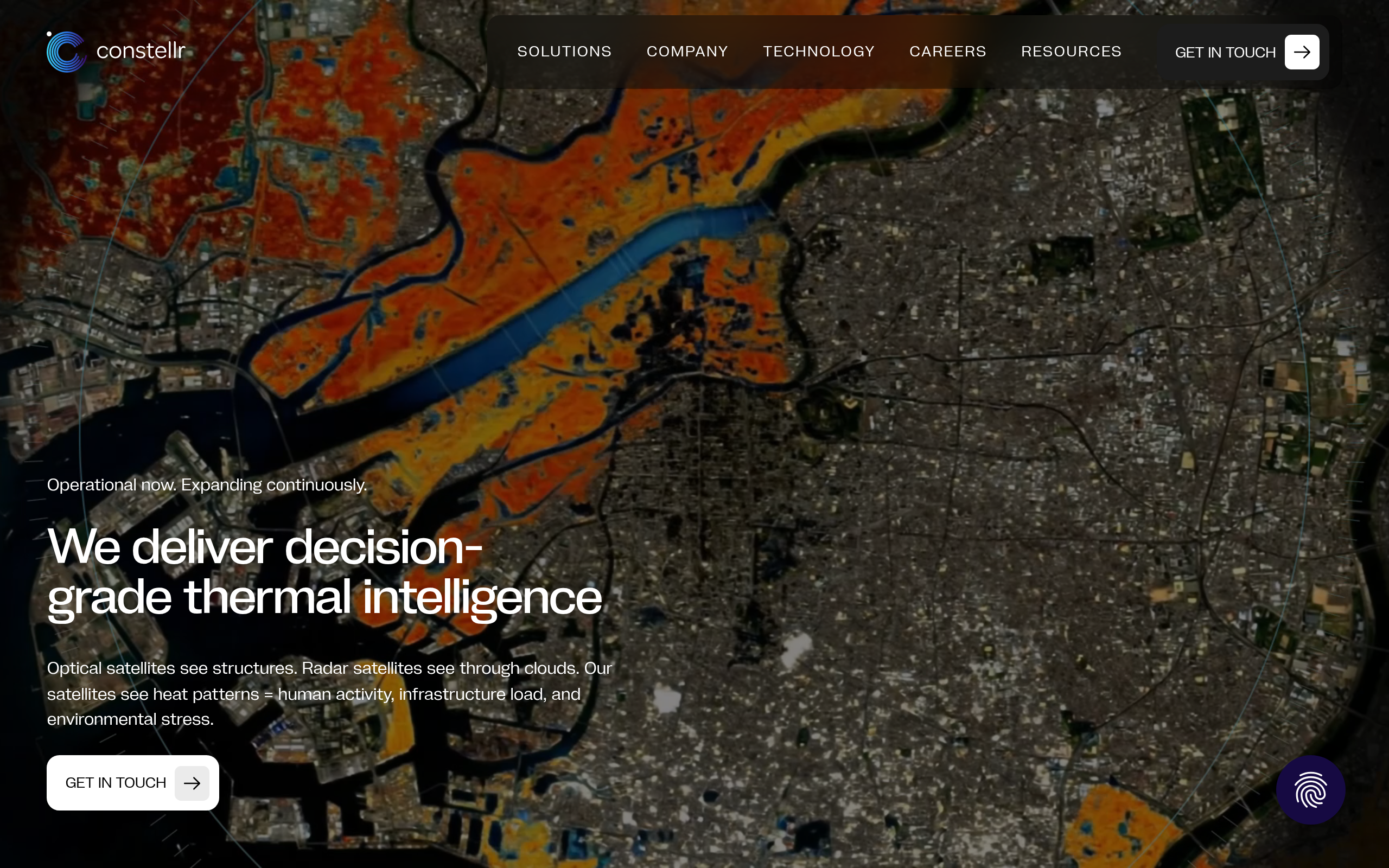
constellr’s ISS demonstrator mission in 2022 validated the thermal technology before any commercial satellite was built, providing engineering evidence that the cryocooled LWIR approach worked at scale. SkyBee-1 achieved first light over Tokyo on March 17, 2025, capturing a building-level 30×30 m thermal grid of the city at night, and SkyBee-2 followed with upgraded sensors on June 24, 2025, confirming two operational commercial satellites within a twelve-month window.
Named institutional relationships include the European Space Agency (Copernicus Contributing Mission and Third Party Mission programme), the European Commission (multi-year contract), Fraunhofer Gesellschaft, DLR, and Airbus as mission partners. The ESA CCM status is a technically rigorous endorsement: ESA validates that the data meets Copernicus quality standards, which carries meaningful credibility for government and scientific buyers.
Compliance and data rights
constellr operates within the European regulatory framework as a German GmbH with an entirely European supply chain, which the company highlights as a sovereign alternative to US-origin thermal data. The ESA Third Party Mission programme, active since January 2026, provides a formal access pathway for non-commercial scientific research through ESA’s established data governance framework.
Commercial data rights and licensing terms are not published on constellr’s site. Buyers working with defence, critical-infrastructure, or dual-use applications will need to engage the sales team directly to understand applicable export and use restrictions for their jurisdiction and application.
Data and capabilities
constellr’s two-satellite HiVE constellation delivers long-wave infrared (LWIR) land surface temperature data in three product tiers, all derived from the same cryocooled sensor payload. The architecture is single-modality by design: constellr does not offer optical imagery, SAR, or hyperspectral products. Thermal LST intelligence is the sole output.
HiVE constellation and sensor specifications
SkyBee-1 and SkyBee-2 operate in sun-synchronous orbit at approximately 510 km altitude on NanoAvionics satellite buses. Each carries a cryocooled LWIR sensor with 4 thermal and 10 visible/near-infrared bands, where the VNIR channels serve geolocation and atmospheric correction rather than serving as a standalone optical product.
The cryocooled detector is notable because thermal sensors at this resolution class normally require either large platforms or performance compromises. constellr’s approach achieves detector sensitivity below 0.1 K on a microsatellite, which the company describes as a first for the platform class.
Published specifications from constellr’s technology page: 27.3 m native GSD at 510 km altitude (rounded to 30 m in product documentation), 1.0–1.5 K absolute surface temperature accuracy, and 0.05–0.15 K noise-equivalent temperature difference (NETD). The two-satellite pair achieves a 1.5-day average midday revisit globally, with day-and-night imaging capability confirmed operational since Q4 2025. Swath width is not published on the company’s site.
Data products: LSTprecision, LSTzoom, LSTfusion
constellr packages its thermal data into three distinct products documented in its UP42 marketplace listing. LSTprecision delivers the native 30 m absolute land surface temperature at high temporal frequency, suitable for programs requiring radiometrically validated LST values for quantitative analysis. LSTzoom sharpens the spatial detail layer to 10 m, enabling building-level and field-level thermal pattern analysis that 30 m native imagery cannot resolve.
LSTfusion is a cloud-free, modelled daily LST product at 30 m that combines constellr measurements with additional data sources to maintain coverage continuity on cloudy days. The specific third-party sources used in the fusion are not named on the company’s site.
All three products are accessible via API, with documentation hosted on constellr’s GitHub. The API-first access model means buyers integrate the data into their own workflows rather than using a hosted visual interface: no self-serve web console has been identified on the company’s public-facing pages.
Constellation roadmap
constellr’s published roadmap targets approximately 30 satellites by 2030, which the SKY Perfect JSAT partnership announcement frames as enabling near-real-time global thermal monitoring. The Series A press release describes next-generation satellites targeting sub-5-meter spatial resolution, which would represent a significant capability step above the current 30 m native and 10 m sharpened products. Annual satellite launches are planned from 2028 per the company’s journey timeline.
Two satellites is the number I keep coming back to in this evaluation. The sensor is the best in its class on the European side, but a constellation this size means the revisit figure is an average, not a promise for a given week, and that is the question I would put to their team first.
The implication for buyers is that the 1.5-day revisit and 30 m native resolution are the current operational baseline, and the roadmap projections are targets rather than committed delivery dates. Programs that require sub-daily revisit or sub-10 m thermal resolution are scheduling against announced intent rather than current capability.
Pricing
constellr does not publish price figures on its own website. Direct commercial access is quote-based, though constellr also lists self-serve products on the UP42 marketplace, alongside a regional distribution partner and a research pathway.
| Channel | Model | Audience | Notes |
|---|---|---|---|
| Direct (constellr.com/contact-us) | Quote-based | Commercial and government buyers | Primary channel for defence, enterprise, and custom programs |
| UP42 marketplace | Marketplace pricing | Commercial developers and analysts | Self-serve published pricing. LSTfusion catalog from 300 credits/km², listed February 2026 |
| SKY Perfect JSAT | Regional distribution | Japan-market buyers | Japan distribution partnership from February 2, 2026 |
| ESA Third Party Mission (TPM) | Research access | Non-commercial scientific research | Announcement of Opportunity accessible from January 26, 2026. Requires pre-coordination with ESA |
The UP42 channel provides the most accessible self-serve route for developers and analysts who want to evaluate constellr data without a direct enterprise conversation. For buyers outside Japan and not affiliated with European research institutions, the direct contact route is the primary path to pricing information.
constellr holds a Copernicus Contributing Mission multi-year contract with the European Commission, which confirms institutional revenue, though the specific financial terms of that contract are not disclosed on the company’s site.
Who it’s for
constellr’s thermal-only architecture and defence-grade accuracy positioning create a focused set of use cases where it is clearly differentiated, alongside sectors where the current constellation scale or access model may be limiting.
Defence, intelligence, and critical infrastructure
The explicit positioning in the Series A announcement as a provider of “defence-grade thermal intelligence” reflects the primary commercial focus. Use cases documented on constellr’s site include concealed activity detection at military and industrial facilities, nuclear reactor and cooling system status monitoring, missile and airbase activity patterns, and maritime vessel wake analysis for dark-ship detection.
The cryocooled LWIR sensor’s 0.05–0.15 K NETD is specifically suited to detecting subtle thermal signatures that lower-accuracy systems would miss, and the European sovereign supply chain addresses procurement constraints for buyers who cannot use US-origin ISR data.
Agriculture, food, and water security
Crop water stress, evapotranspiration monitoring, and irrigation efficiency assessment all rely on land surface temperature as the primary input variable, and constellr’s 30 m native resolution maps directly onto field-scale analysis. The 1.5-day midday revisit is sufficient for weekly crop stress monitoring and aligns with typical agricultural decision cadences, though it falls short of the daily revisit that some precision irrigation workflows require.
The LSTfusion cloud-free product addresses a common pain point in agricultural thermal applications, where cloud cover would otherwise create multi-day data gaps during critical growth periods.
Urban dynamics and climate monitoring
Urban heat island mapping, infrastructure heat loss detection, and climate monitoring programs that treat land surface temperature as an Essential Climate Variable (ECV) are documented use cases on constellr’s site. The 10 m LSTzoom product enables block-level thermal analysis relevant to urban planning, heat vulnerability assessments, and green infrastructure evaluation. The ESA CCM relationship confirms that the data meets the quality standards used in European climate monitoring programs.
Where it’s less competitive
With two operational satellites, constellr cannot yet match the global revisit frequency that larger optical constellations offer for broad-area monitoring programs. Buyers who need sub-daily thermal revisit for continuous facility monitoring will find the 1.5-day average revisit a meaningful constraint, and the constellation roadmap toward daily revisit “for target regions” remains a target rather than a current capability.
Programs requiring optical, SAR, or hyperspectral data alongside thermal will need to source those from separate providers, as constellr does not aggregate or resell non-thermal imagery. The absence of published pricing and a self-serve archive means that evaluation requires direct engagement or an UP42 account, which adds friction compared to operators with transparent self-serve pricing.
Strengths and limitations
constellr’s differentiation rests on sensor performance and provenance, not on constellation scale. The strengths concentrate in accuracy, European sovereignty, and institutional validation:
- Cryocooled LWIR sensor achieving 1.0–1.5 K absolute temperature accuracy and 0.05–0.15 K NETD on a microsatellite platform, a validated technical first endorsed by ESA as a Copernicus Contributing Mission
- Three distinct thermal product tiers (LSTprecision at 30 m, LSTzoom at 10 m sharpened, LSTfusion cloud-free modelled daily) covering different precision, resolution, and coverage trade-offs from a single operator
- Fully European supply chain with a German GmbH structure, subsidiaries in Brussels and Toulouse, and ESA institutional backing, addressing sovereign data procurement requirements that US-origin thermal data cannot satisfy
- Clear scale roadmap to approximately 30 satellites by 2030 and sub-5-meter next-generation resolution, with EUR 75M in total disclosed equity backing the buildout
- Multiple access channels including direct contracts, UP42 marketplace, and ESA TPM research pathway, representing more commercial access points than most early-stage satellite operators at the two-satellite stage
The limitations are worth assessing against your program’s timeline and access requirements before committing:
- Two-satellite constellation: 1.5-day average global revisit is the current operational reality, not a target. Daily revisit for priority regions remains a roadmap item
- No published pricing and no self-serve archive yet (as of early 2026 per ESA TPM announcement). Commercial evaluation requires a direct conversation or an existing UP42 account
- Single modality: constellr delivers thermal LST data only. Optical, SAR, and hyperspectral requirements need separate providers
- Next-generation sub-5-meter resolution and the 30-satellite constellation scale are roadmap targets. Buyers planning around those capabilities are scheduling against announced intent, not confirmed operational specifications
- Swath width is not published on the company’s site, which makes area-coverage planning for large-scale programs harder to estimate without direct engagement
The core commercial tension is timing: constellr’s sensor technology is validated and operationally proven, but the constellation is at the earliest stage of its intended scale. For programs where European-sovereign thermal accuracy is the decision driver, there is no direct European-operated alternative at comparable sensor performance. For programs where revisit frequency or broad-area coverage is the primary need, the current two-satellite baseline requires realistic expectations.
constellr alternatives
If constellr’s current constellation scale or access model does not fit your timeline, three operators offer meaningfully different thermal or thermal-adjacent capability profiles. The table below draws on verified specifications from primary sources for each provider.
| Provider | Best thermal resolution | Revisit | Constellation | Key differentiator |
|---|---|---|---|---|
| constellr | 10 m (LSTzoom sharpened), 30 m native | 1.5-day average (2 satellites) | HiVE (2 operational SkyBee satellites) | Cryocooled LWIR at 1.0–1.5 K absolute accuracy, European sovereign supply chain, ESA CCM validated |
| SatVu | 3.5 m thermal (HotSat-2) | Sub-daily revisit target (scaling constellation) | HotSat constellation, UK-operated | Highest published thermal resolution in commercial operation, strong industrial and security applications |
| OroraTech | ~200 m (Forest-2 class), multi-sensor fusion | Near-hourly via multi-satellite aggregation | Own smallsats plus aggregated thermal data | Wildfire detection and climate monitoring focus, high revisit through sensor fusion, established commercial product |
| Hydrosat | ~30 m (thermal-optical fusion) | Daily via Landsat/ECOSTRESS fusion | HydroSat-1 own satellite plus aggregated sources | Agriculture-focused evapotranspiration and water stress analytics, daily coverage via data fusion |
SatVu’s HotSat-2 currently publishes the highest commercial thermal resolution at 3.5 m, making it the closer comparison for buyers where spatial detail at the building or equipment level is the primary driver. OroraTech’s near-hourly revisit through multi-sensor aggregation serves wildfire and climate monitoring programs where temporal density matters more than absolute radiometric accuracy.
Hydrosat’s fusion approach delivers daily thermal coverage for agricultural use cases at comparable 30 m resolution, with an analytics layer focused on evapotranspiration and crop water stress.
constellr’s differentiation among these three is the combination of validated cryocooled sensor accuracy, the European sovereign provenance, and the stated trajectory toward sub-5-meter resolution at 30-satellite scale, a roadmap that none of the three alternatives currently matches.
constellr features in our ranking of the best thermal satellite imagery providers.
Verdict
constellr is a legitimate, technically validated satellite operator with two operational cryocooled thermal-infrared satellites, EUR 75 million in disclosed funding, and ESA Copernicus Contributing Mission status. The company is not a speculative pre-launch venture: SkyBee-1 and SkyBee-2 are imaging Earth, the data is available through UP42 and direct contracts, and the sensor accuracy has been independently validated by ESA.
For buyers whose primary requirement is high-accuracy European-sovereign thermal intelligence, constellr is the only operational provider in its class. The 1.0–1.5 K absolute accuracy, cryocooled LWIR sensor, and ESA CCM validation form a capability combination that no comparable European operator currently offers. Defence, intelligence, and critical-infrastructure buyers with sovereign data requirements will find few credible alternatives at this specification level from a European supply chain.
The caveats are structural and temporal. Two satellites deliver a 1.5-day revisit that is operationally useful but not sufficient for continuous real-time monitoring. Published pricing does not exist, so every commercial evaluation begins with a sales conversation. The 30-satellite scale and sub-5-meter resolution that would make constellr broadly competitive on revisit and spatial detail remain roadmap targets through 2028–2030.
For programs where those parameters are fixed requirements now, the alternatives table above is the practical starting point. For programs where European-sovereign thermal accuracy is the decision driver, constellr’s current capability is the relevant benchmark.
Frequently asked questions
Below are answers to the questions buyers most commonly ask about constellr. Each answer points to the section where the full detail lives.
How does constellr work?
constellr operates two thermal-infrared microsatellites in sun-synchronous orbit and delivers land surface temperature data through three product tiers: LSTprecision (30 m), LSTzoom (10 m sharpened), and LSTfusion (cloud-free daily), all accessible via API, UP42, and direct contracts. The company provides a Constellation-as-a-Service model where buyers pay for data rather than owning infrastructure. Full detail is in the “Data and capabilities” section.
Is constellr a legit company?
Yes. constellr GmbH is registered at Munich District Court (HRB 309090), has raised EUR 75 million in disclosed equity, and operates two confirmed commercial satellites whose data has been validated by ESA as a Copernicus Contributing Mission. The ESA CCM status is a technically rigorous third-party endorsement that distinguishes it from unvalidated early-stage operators. See “Is constellr legit?“
Who owns constellr?
constellr GmbH is a private German company backed by Alpine Space Ventures, Lakestar, the EIC Fund, Fraunhofer Technologie-Transfer Fonds, Vsquared, and CosmiCapital following the February 2026 Series A. Dr. Max Gulde is CEO and Co-Founder, and no parent company or acquirer is listed. Ownership context is in the “Is constellr legit?” section.
How much does constellr cost?
constellr does not publish prices on its website. Commercial access is quote-based via direct contact or the UP42 marketplace, with regional distribution in Japan through SKY Perfect JSAT. Non-commercial scientific research is accessible through the ESA Third Party Mission programme at no cost to qualifying researchers. Pricing context is in the “Pricing” section.
Does constellr have a free tier?
constellr does not offer a public free trial or self-serve evaluation tier. The ESA Third Party Mission programme provides data access for non-commercial scientific research, but it requires pre-coordination with ESA and is not a self-serve commercial evaluation pathway. Details are in the “Pricing” section.
Where is constellr based?
constellr GmbH is headquartered at Planegger Str. 13, 81241 München (Munich), Bavaria, Germany, and was originally founded in Freiburg, Germany. The company operates subsidiaries in Brussels, Toulouse, and Washington D.C., reflecting active engagement with EU institutional and US government markets. Full address is in the “About constellr” section.
When was constellr founded?
The exact founding year is not stated on constellr’s own website. The company’s published timeline shows a 2022 ISS demonstrator mission as its first documented milestone, and its first commercial satellites launched in 2025. constellr states it was founded in Freiburg, Germany, before the ISS demonstrator phase. Background is in the “About constellr” section.
Who are constellr’s customers?
Named institutional relationships include the European Space Agency (Copernicus Contributing Mission and Third Party Mission programme), the European Commission (multi-year contract), Fraunhofer Gesellschaft, DLR, and Airbus as mission partners. Commercial distribution partnerships with UP42 and SKY Perfect JSAT suggest a growing developer and regional government customer base. The full customer context is in “Is constellr legit?“
How does constellr make money?
constellr’s primary revenue model is Constellation-as-a-Service: buyers pay for thermal data products and analytics access through direct contracts, the UP42 marketplace, or regional distribution partners, without owning any satellite infrastructure. The multi-year Copernicus Contributing Mission contract with the European Commission provides institutional contract revenue. Defence and government programs represent a growing share of the pipeline following the Series A positioning shift. See “Pricing” for the access channel structure.
What are the best alternatives to constellr?
The closest matches depend on your primary requirement: SatVu for the highest published commercial thermal resolution at 3.5 m, OroraTech for near-hourly wildfire and climate monitoring through multi-sensor aggregation, and Hydrosat for daily agricultural thermal coverage via data fusion at comparable 30 m resolution. A full comparison is in the “constellr alternatives” section.
What use cases is constellr best suited for?
constellr is strongest for defence and intelligence applications requiring European-sovereign thermal ISR, critical infrastructure monitoring, maritime dark-vessel detection, agricultural crop water stress, urban heat island mapping, and climate programs that require land surface temperature as an Essential Climate Variable. It is less competitive for programs that need sub-daily revisit or optical and SAR data alongside thermal, which requires additional providers. Details are in the “Who it’s for” section.

My passions are Earth Observation and Satellites, and my profession is Data Analysis. I combine both within ObservationData.com to show you the use cases of Earth Observation, to help you find the right provider, and to share your experiences.